URAY RESEARCH : : KHANTY–MANSI AUTONOMOUS OKRUG
Pre-project research of urban open spaces in Uray town. Includes community participation events substantiating the choice of territories for creation of public spaces
Uray, Khanty-Mansi Autonomous Okrug, Russia
client: municipal public institution Uray Urban Planning, Land Use and Natural Resource Management Administration
August–September 2019
The study includes several semantic parts, separated by the method of data collection and processing: indoor research | field research | open urban space analysis | areas for placemaking
REMOTE DATA COLLECTION AND URBAN ENVIRONMENT ANALYSIS
- Analysis of connectivity, pedestrian and transport accessibility of open urban public spaces in the city Uray;
- collection and analysis of information on urban and local active communities, interest communities, urban activists and business representatives;
- assessment of formats for using public spaces d. Uray;
- Assessment of urban environment factors and their impact on the objects located in the adjacent public spaces of the Uray city.
Analysis of connectivity, availability and formats of open urban spaces
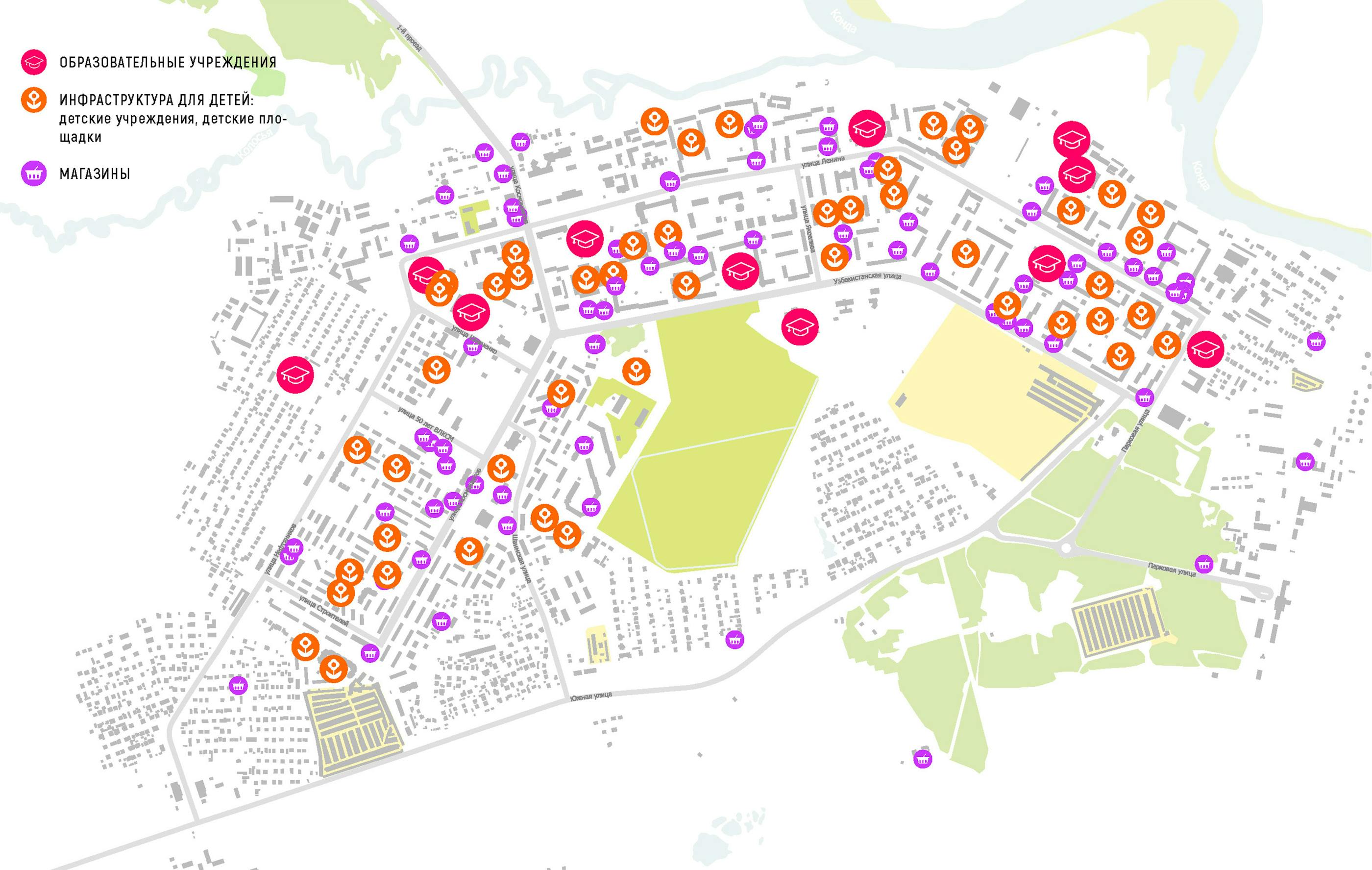
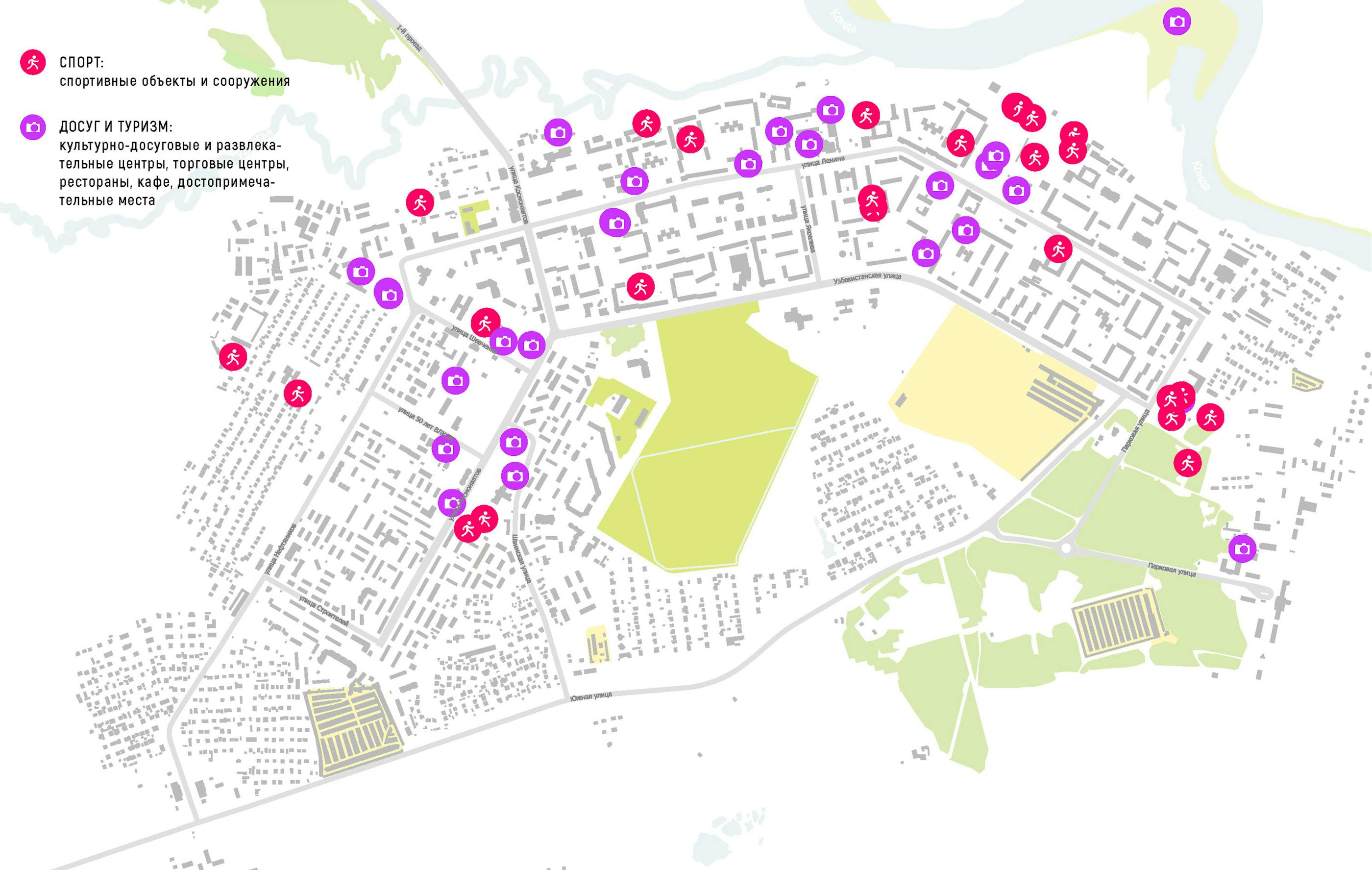
On the basis of the open data of the service openstreetmap.ru the following information was received placement of objects of various functional purposes and mapping of such objects according to four categories: intended stay, episodic use, daily use, sports and leisure.
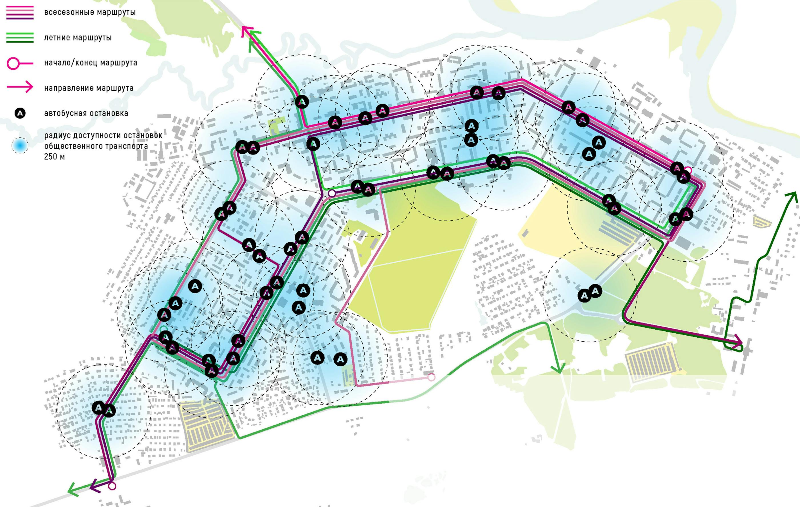
On the basis of GPS-track services STRAVA and Yandex.Maps pedestrian tracks and transport connectivity and accessibility of the city's spaces were identified. Uray. It follows from the analysis: open urban spaces, concentrated in the northern part of the city and located parallel to the east-west direction, are provided by an order of magnitude higher passenger traffic. The development of such spaces is important for the whole city. Their users are residents of both the centre and the periphery. The development of open urban spaces in the southern and southeastern parts of the city in the current transport situation may be more of a "local", micro-district nature.
Assessing urban environment factors and their impact on urban open spaces
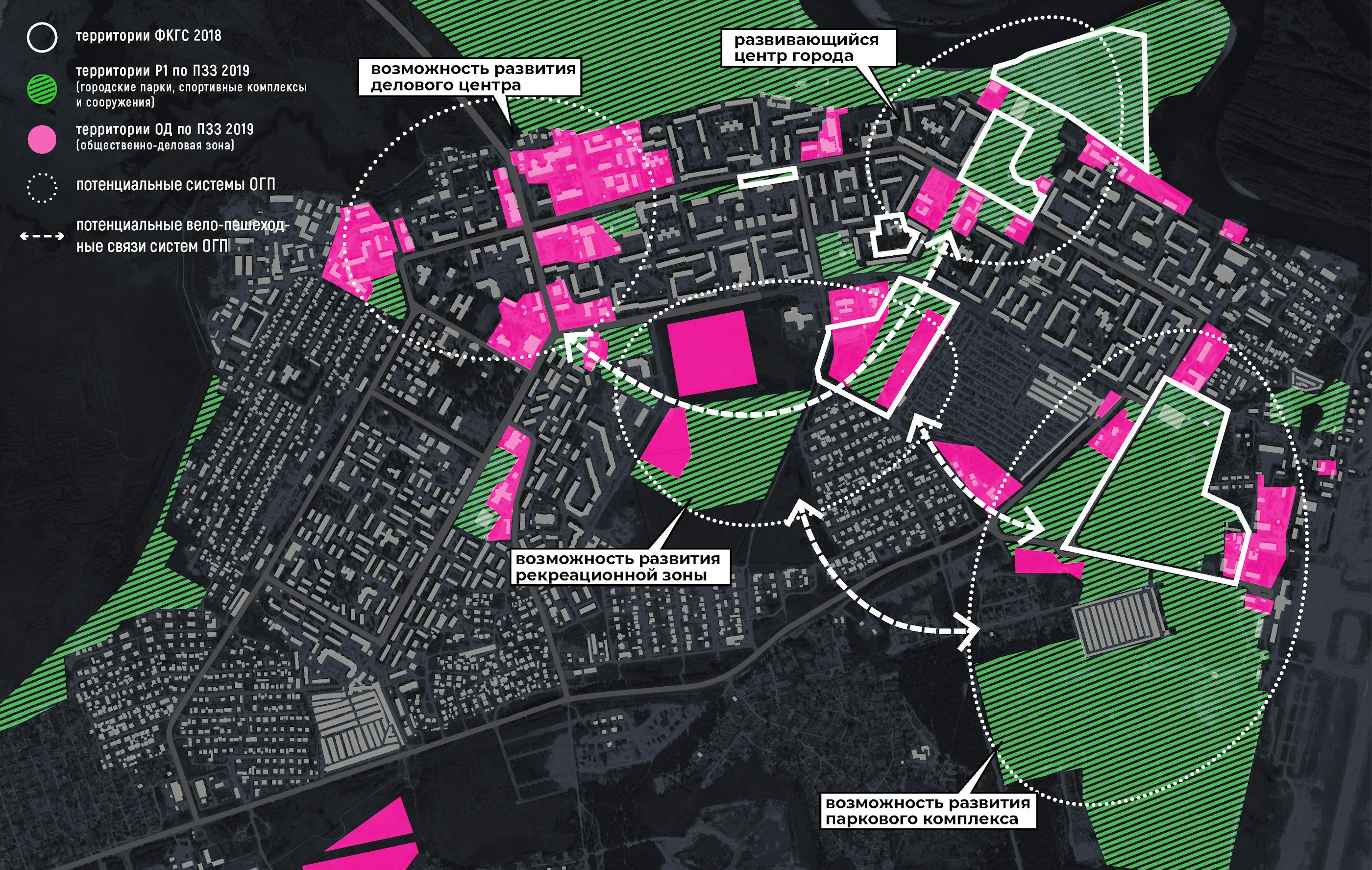
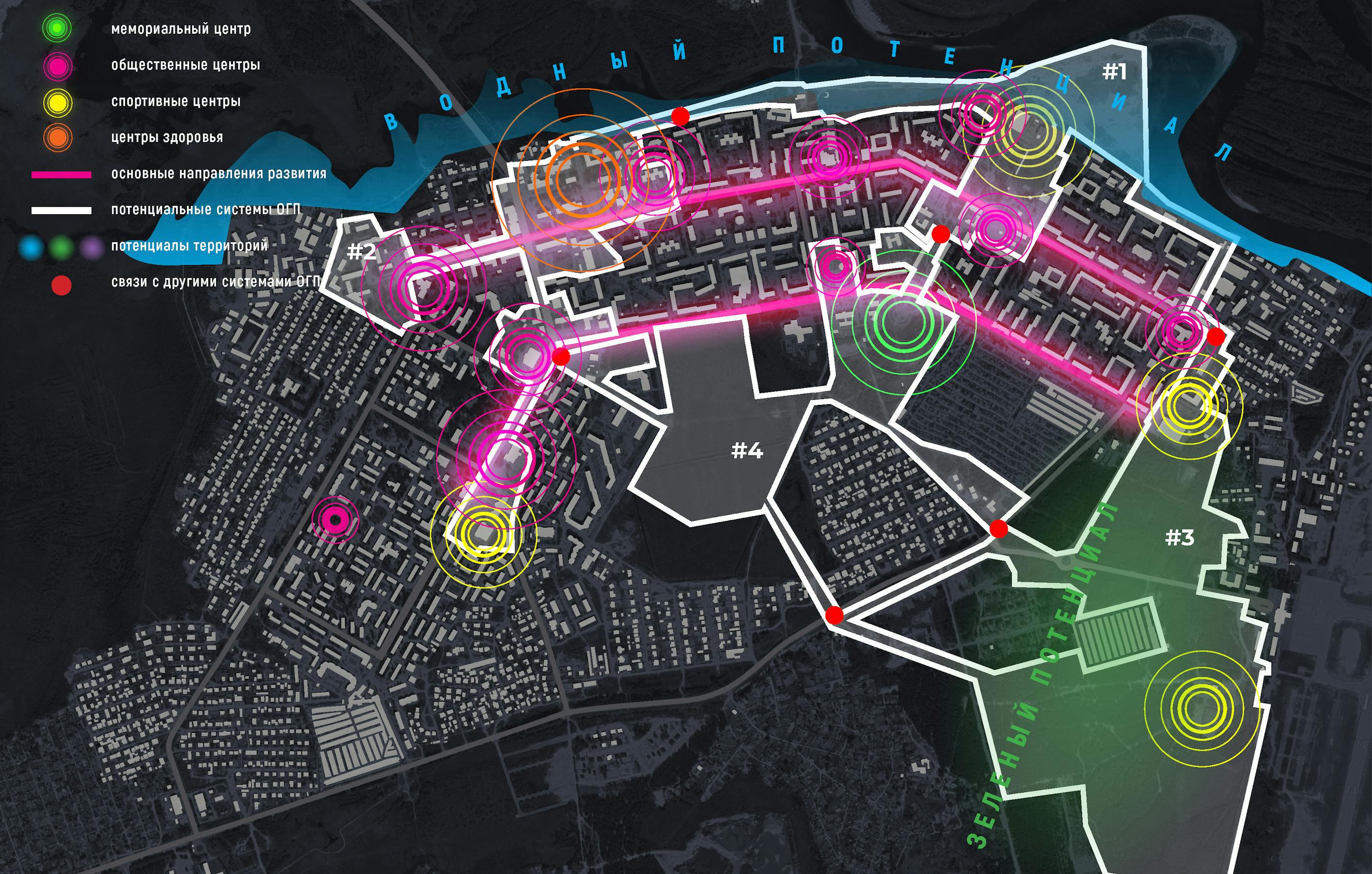
In 2018, during the events held within the Russian priority project Development of Comfortable Urban Environment, there were collected opinions and suggestions of Chistopol citizens. Combined with town planning documentation, these suggestions became the ground for the plan of the town’s public, business and recreational zones. Remote data analysis allows it to single out four potential systems of urban open spaces (UOS) which require cycle and pedestrian connections. There were suggested four formats of urban spaces use, one for each UOS system.
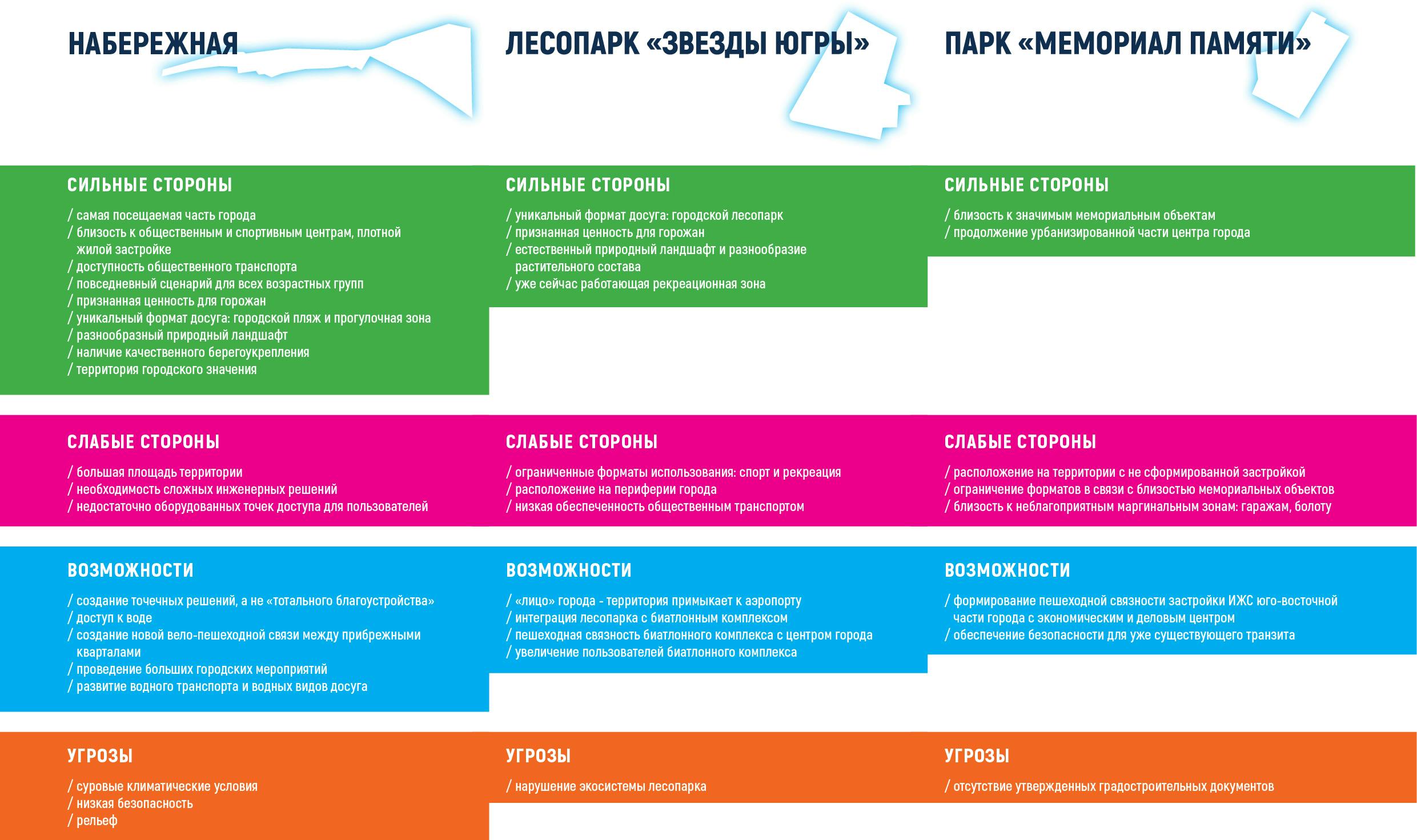
- #1 «CENTER» town center development at Lenina street for a group of urban open spaces including a number of sport facilities and an embankment.
- #2 «BUSINESS CENTER» development of the city’s business center for a group of public and business territories at Lenina and Kosmonavtov streets.
- #3 «YUGRA STARS URBAN FOREST» development of a park zone on the basis of the urban forest and the biathlon complex.
- #4 «THE MEMORIAL» development of a recreational zone for the future recreational, public, and business territories on the place where there is currently a moor and a bog.
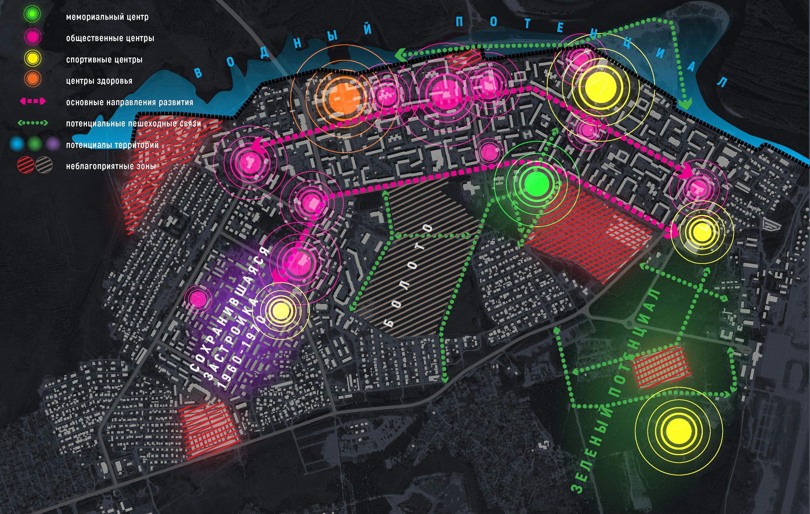
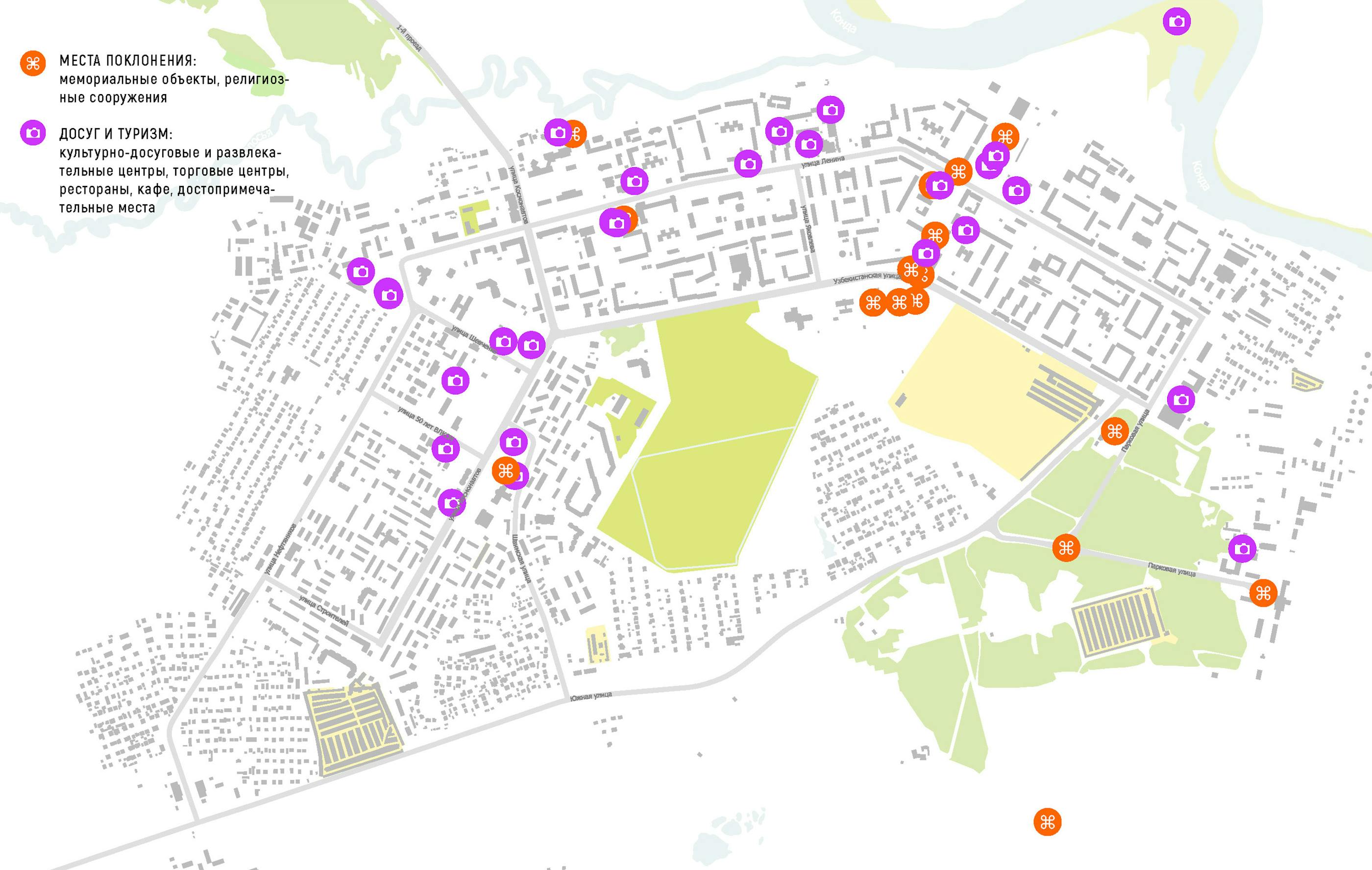
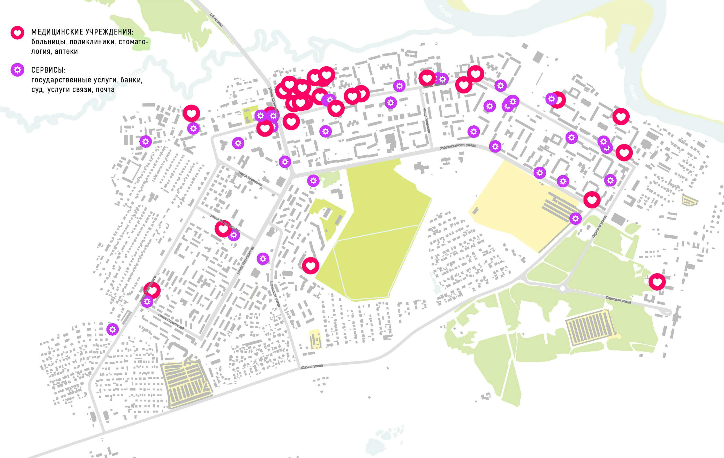
The collected data on Uray includes the position of the places of interest used with different frequency and the places where local communities are gathering. Based of this data, there was made assessment of urban environment factors and their influence on the objects placed on the territory laying close to urban spaces. Remote analysis allowed it to single out medical, memorial, sports, and public centers which can be found along the main axes of spacial development —Lenina street, Uzbekistanskaya street, and Kosmonavtov street. These centers are the places where town’s communities or a big group of users are gathered. Subsequently, they influence the territories and public spaces laying close to them.
The positive urban factors of Uray are:
- water potential of the town’s rivers, Kolosye and Konda’s banks and potential of areas laying near these banks;
- cultural potential of the residential complexes in microdistricts 1Д, 1Г, 2А;
- natural and recreational potential of a forest and an urban forest.
- The negative urban factors of Uray are:
- a bog and garages which appear to be obstacles for the creation of pedestrian and transport connections between the districts of the south-eastern part of the town;
- absence of equipped transport, cycle, and pedestrian network, together with disruption of the town’s fabric in its south-eastern part, seriously undermine safety in the town.
Field research and social data analysis
- preparation and carrying out of measures on co-projecting in the city of Uray with the organization of voting for the choice of territory from the list of the proposed ones, taking into account the arguments of the preliminary and field research;
- Preparation of a manual on social data collection for the local team;
- Analysis of collected social data;
- Study of existing territorial use scenarios;
- study of the socio-cultural landscape of the territories;
- Study of the cultural code of the city in the form of a walking tour from local leaders of urban communities.
Research of existing usecases for the territories
As part of the pre-project research of open urban spaces for data collection and convenience of working with a local team of volunteers in field research, a tool for mapping stationary activities has been developed. The purpose of this tool is to identify formats of use and established practices implemented in the open urban spaces, as well as audiences.
POPULARITY OF URBAN OPEN SPACES WITH URAY CITIZENS
Comparative analysis of opinions on popular places within an urban environment revealed the following patterns:
- People do not perceive each other in the town.
- People are limited in their choice of a form of spending free time.
Analysis of social data of different age groups allowed to to make the following conclusions: people do not perceive each other in an urban environment, which limits their social communication. For instance, it was discovered that the elderly and the young gave very different answers to the question on where people of the third age group spend their free time. Older citizens rarely use urban environment, except for those who have children in their family. The elderly believe that the young “aimlessly wander” around the town.
According to the sociological study, the citizens indicate Solnyshko Park, the embankment, Recreation and Leisure Park, TPP Park and Pervootkryvateley Square as most popular spaces. The citizens are actively using sports facilities, including Neftyanik Stadium and the biathlon track (ski base), which are even more popular than parks and other public spaces. However, the citizens believe that people of age groups different from their own are occupied with stereotyped things like being “at home”, “at work”, “on street benches”, walking “outside”, spending time “in cafes”. Public spaces are almost never mentioned, and Solnyshko Park, Recreation and Leisure Park and the ski base were mentioned the least.
About a half of the respondents prefer to spend time at home, which speaks both of a lack of possible scenarios and forms of leisure and of their inability to identify with urban environment.
Having mentioned all that, it is possible to draw the following conclusion: different age groups know little about each other’s behavior within urban environment, mainly due to the fact that they rarely cross each other’s paths.
Research of the city's cultural code
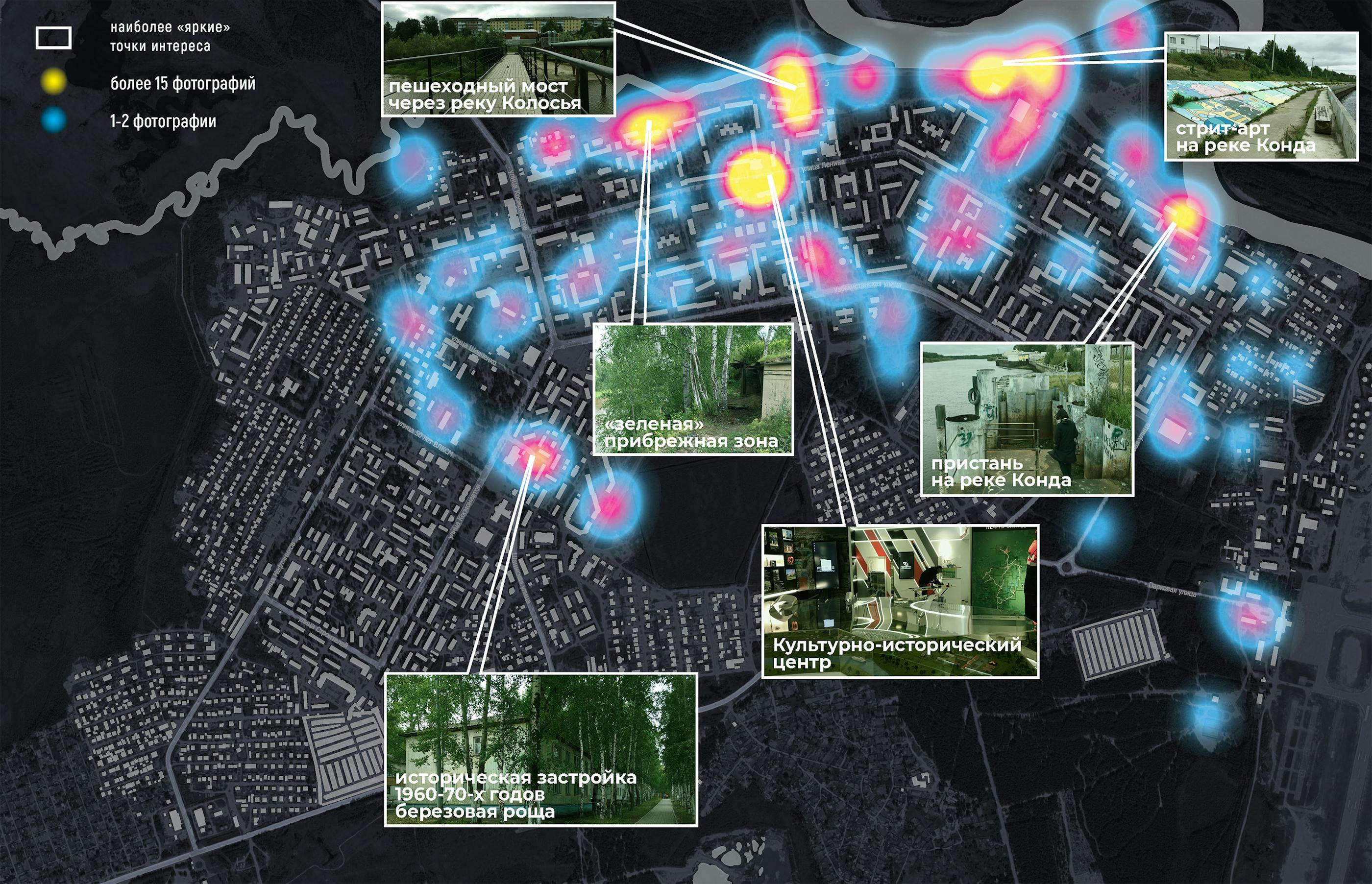
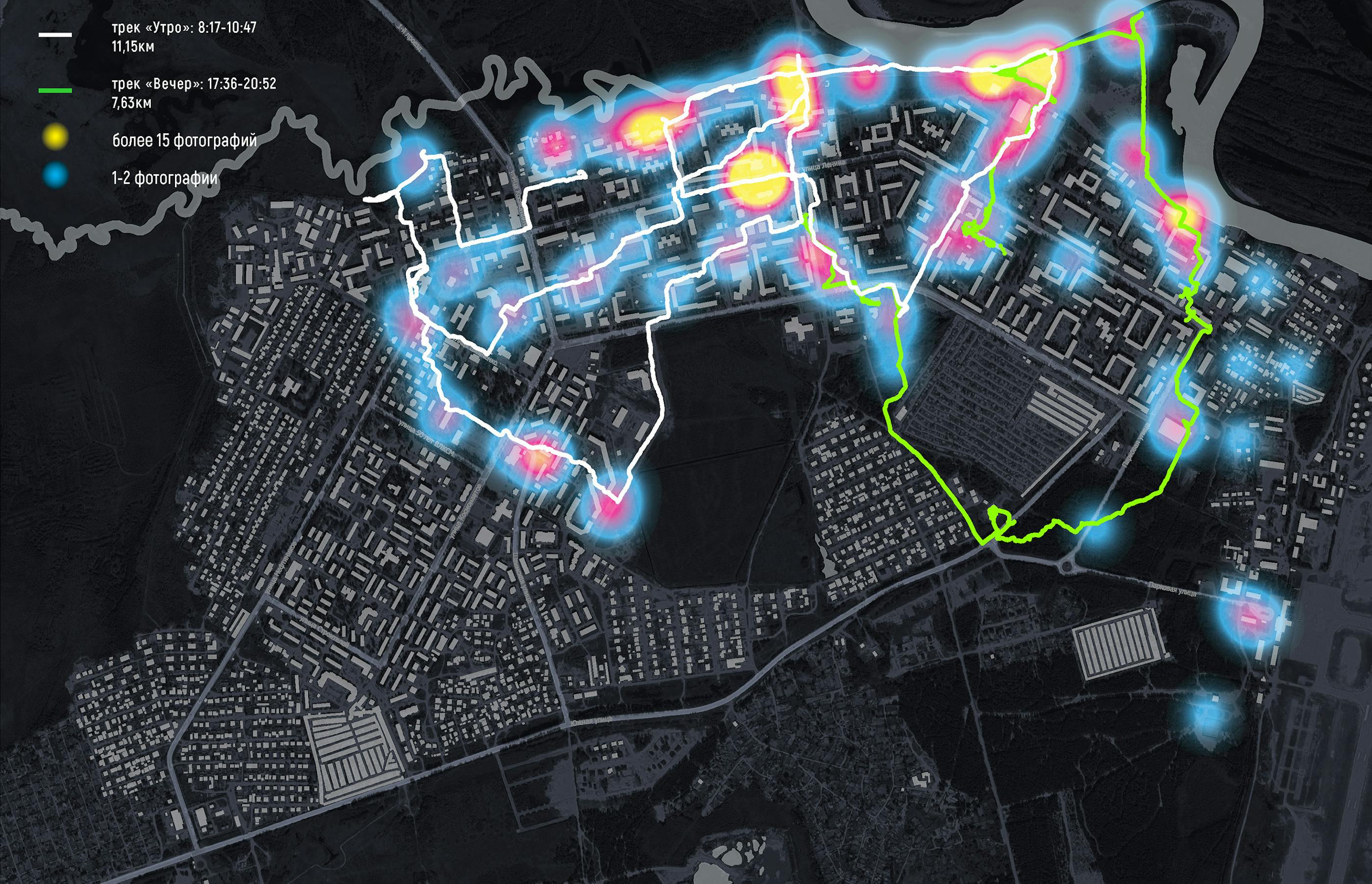
On the first day of the field research, a study of the city of Uray was conducted in the form of a walking tour. The aim was to gain experience in the use of spaces and identify their different typologies, look at the city "through the eyes of a tourist", and observe. This practice allows to recognize the potentials and properties that are not available for the tools used in the cameral part of the study.
Heatmap is driven by geo-referenced photos. It reflects the number of photos taken at each location. It may indicate its uniqueness, significance, potential, obvious positive or negative properties from the observer's point of view. This allows hypotheses to be made about the presence of both local points of interest and entire areas with strong development potential.
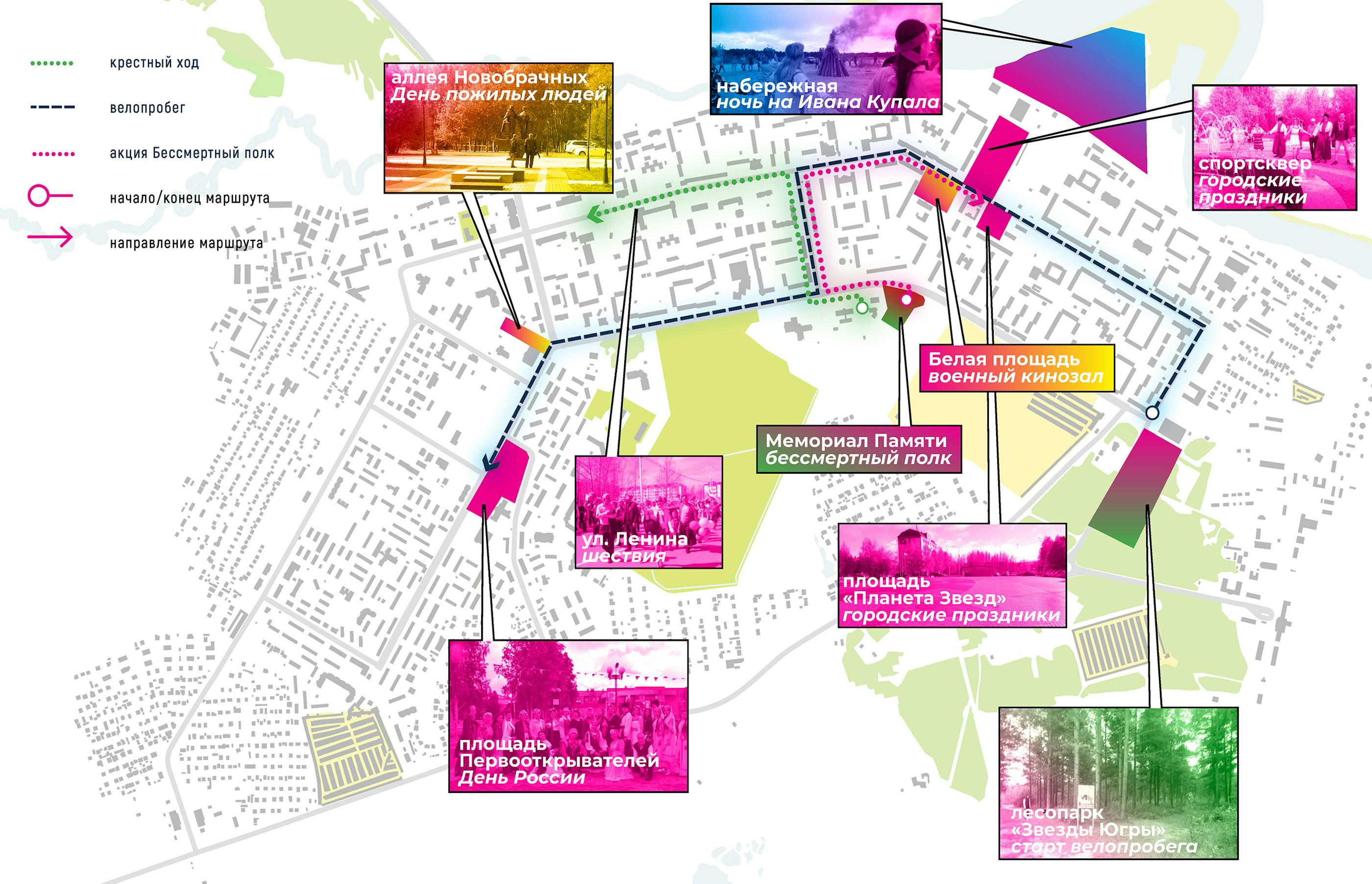
At the tour with the leaders of urban communities were presented public spaces, the most popular in the festive scenarios of the city of Uray.
SYSTEMS OF URBAN OPEN SPACES IN URAY
The following four potential points of growth were discovered within the study of Uray’s urban open spaces:
- #1 «CENTER» Sports Garden — White Square — Planet of Stars Square — Neftyanik Stadium.
- #2 «BUSINESS CENTER» A cluster of social and business facilities at the intersection of Lenina and Kosmonavtov streets — Romantikov Garden — TPP Park — Novobrachnykh alley.
- #3 «YUGRA STARS URBAN FOREST» Yugra Stars Sports Palace — Yugra Stars Landscape Park — biathlon complex.
- #4 «THE MEMORIAL» The Memorial is a potentially recreational zone, the zone of a future social and business development, currently a bog.
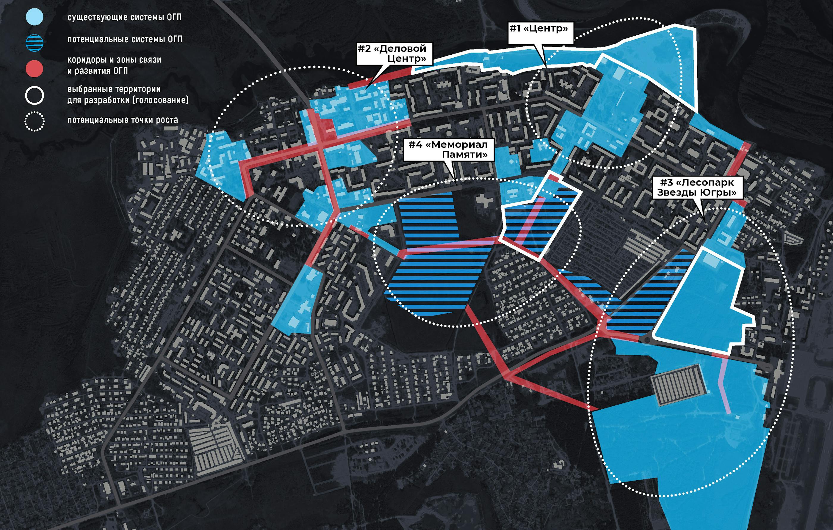
Detailed consideration of components of potential points of growth revealed the borders of urban open spaces in Uray and connections between them. Further analysis of each of them will allow it to predict development of public spaces of the town, fortify positive characteristics of each of it’s centers and offset negative aspects which may occur in the urban environment.
POTENTIAL FOR IMPROVEMENT
Around half of the citizens chose natural sights as those they would prefer to have improved, explaining that “there are no pleasant urban forest or park zones in Uray”. Together with the results of an online poll held during the seminar session, the results of processing ballot papers showed that, according to Uray citizens, the territories which need improvement the most are the embankment, Memorial Park, and Yugra Stars Landscape Park.
- Embankment Following the opinion of the citizens, this is one of the most popular sights. Even though Neftyanik Stadium is a magnet for the young of the town, the embankment is a main and favorite green zone for walking in silence, watching flora and fauna of the district, contemplating Konda river valley. Together with the territory of a Sports Garden, which is a part of Recreation and Leisure Park where you can find food points and infrastructure, embankment has very high potential for the development of recreation in the center of the town.
- Memorial Park Citizens believe that this would be the right spot for creating a recreational zone for walking dogs and safe pedestrian connection between the south-western microdistrict and the northern part of the town.
- Yugra Stars Landscape Park Citizens’ favorite green zone for walking in silence, this big territory having diverse vegetation and laying in relative proximity to the center of the town has great potential for becoming Uray Town Park. In order to develop a productive plan for urban improvement of Uray, it is important to find solutions which would preserve the existing natural landscape as much as possible.